Climate Change Dialogue 2020: Integrated coastal protection
CBSS Baltic Sea Region Climate Policy Dialogue Platform 10th roundtable meeting on 10 December took a closer look at CASCADE project outputs related to new and emerging climate risks with particular focus on integrated coastal protection.
Due to sea level rise, absence of ice and more frequent and stronger winter storms, increases in the rate of coastal erosion have been noticed in all Baltic Sea Region countries. All European countries have mapped flooding risks including coastal floods and are taking measures for early warning and protection against floods, but coastal erosion risk areas are mapped by few. Participants exchanged experiences how coastal erosion issues are currently addressed in various Baltic Sea Region countries and the meeting emphasized the need for more cooperation among the relevant authorities to lean from best practices in our Region to increase resilience of coastal regions against long term risks related to sea-level rise and apply integrated and nature-based solutions against coastal erosion.
Agenda
| 09:45 –10:00 | Participants sign in to online meeting. |
| 10:00 – 10:05 | Start of the meeting Welcome by the Chair of the meeting. |
| 10:05 – 10:10 | Introduction of the agenda and purpose of the meeting (CBSS Secretariat) |
| 10:10 – 10:30 | CASCADE Overview of climate risk drivers, hazards and consequences in BSR (SEI Tallinn) One task of the HA Climate initiated CASCADE – Community Safety Action for Supporting Climate Adaptation and Development – project, was to update climate risks in BSR identified during preparation of the BALTADAPT Strategy and Action Plan in 2013. Based on newest climate research data some negative impacts of emerging climate change were identified which are not yet in political agenda in BSR but need urgent response. Presentation is providing overview of those new risks. |
| 10:30 – 11:00 | Mapping Coastal erosion risks in Sweden (SWEDGEO) In order to address properly climate risks, one should know exposure and vulnerability of coastline. When all countries in BSR have prepared flood-maps, only few countries have mapped also risks of coastal erosion, Swedish example is presented. |
| 11:00 –11:20 | Danish municipalities cooperating on coastal protection (Danish Coastal Authority) As negative impacts of climate occur at local level, the role of Local Governments is crucial in increasing resilience. Example of municipal actions and cooperation from Denmark will be presented. |
| 11.20 – 11.40 | Lithuanian experience, Ministry of Environment (TBD) |
| 11:40 –12:00 | EU coastal protection policies (EU Commission DG CLIMA) EU policies aiming coastal protection are somewhat fragmented and divided between DG Envir, DG Mare and DG Climate. Does new EU Climate Adaptation Strategy have more integrated approach responding to climate risks related to sea level rise and increased storm-surges, will be presented. |
| 12:00 –12:30 | Discussion on initiatives to address coastal erosion in BSR (All participants) Participants are encouraged to share their experience on national and local initiatives to assess and respond to coastal erosion in their respective countries and propose joint actions in BSR to increase resilience to sea-level rise. |
| 12:30 | End of the meeting |
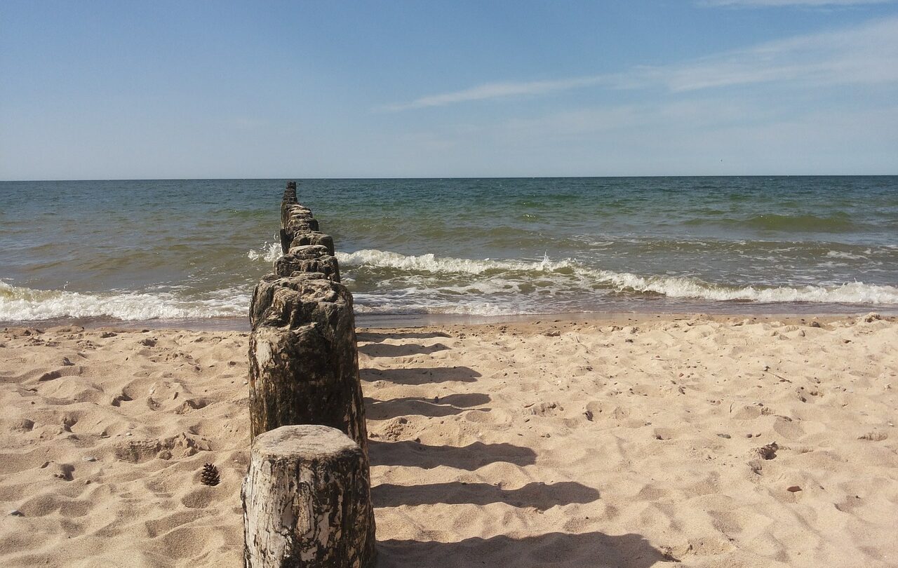
Coastal erosion in the Baltic Sea Region
Rising sea waters, more frequent and stronger storms are increasing flood risk in coastal areas around the Baltic Sea Region and erosion in the south; at the same time, many coastal municipalities seek to take advantage of the qualities of coastal locations by developing urban areas closer to the sea.
According to The Baltic Marine Environment Protection Commission – also known as the Helsinki Commission (HELCOM) assessment, all countries along the southern Baltic Sea shore suffer from coastal erosion:
🇩🇰 In Denmark, the most visible erosion has taken place at capes and cliffs, with cliff erosion amounting to 0.2–0.5 m/year on average.
🇩🇪 On the German coast, major erosion takes place at capes and cliffs in the region of Kiel Bay (on average, 0.3–0.4 m/year), on the islands of Rügen and Usedom, and east of Rostock.
🇵🇱 On the Polish coast, the average coastal retreat in the period 1875–1979 was 0.12 m/year, increasing to 0.5 m/year in the period 1960–1983, and 0.9 m/year in 1971–1983. Erosion processes are now present over 74% of the Polish coast. Owing to this, coastal defense structures have been erected along 26% of the Polish coast.
🇱🇻 In Latvia, over the past 50–60 years, long-term cliff erosion has occurred at the rate of 0.5–0.6 m/year, reaching a maximum of 1–1.5 m/year along certain stretches of the coast. Since 1980/1981, the rates of erosion along the Latvian coast have increased to 1.5–4 m/year.
🇱🇹 In Lithuania, a similar situation has also been observed along the coast.
🇪🇪 In Estonia, there has been increased activity of both erosion and accumulation processes in recent decades.
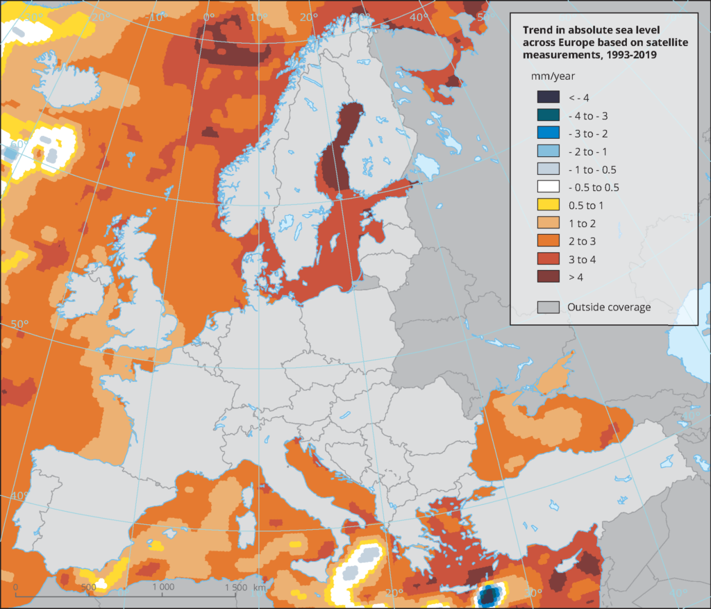
European Environment Agency states that a collapse of marine-based sectors of the Antarctic Ice Sheet (i.e. those areas where the bed lies well below sea level and the edges flow into floating ice shelves) could cause GMSL to rise substantially above the likely range projected for the 21st century, but the evidence is currently insufficient for estimating the likelihood of such a collapse. A structured expert assessment suggests that a GMSL rise of 2 or more meters cannot be ruled out.
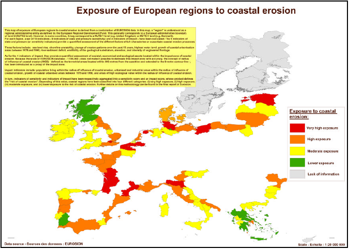
EUROSION project mapped coastal erosion vulnerability and countries of Southern Baltic were considered from moderately to highly exposed to coastal erosion.
CASCADE project highlights that only five of the Baltic Sea Region countries have included flooding or extreme weather event related cascading effects for Critical Infrastructure in their National Risks Assessments.
According to the European Commission’s Directive on Maritime Spatial Planning (MSP), the EU coastal states are obliged to develop national maritime spatial plans by 31 March 2021 at the latest. These plans need to fulfil several requirements, including taking account of land-sea interactions, following an ecosystem-based approach, ensuring coherence between MSP and other processes, and enabling transboundary cooperation between EU Member States.
ESPON-TITAN (Territorial Impacts of Natural Disasters) Project interim report (July, 2020) states that storm hazard map clearly shows that the areas most affected by windstorms are coastal regions of the North Sea and exposed coastal areas of the Baltic Sea. As a general observation, this implies that particularly coastal areas must take this hazard into account in planning systems, and along with rising sea levels caused by climate change even more so. Windstorm events have impacts on local coastal erosion patterns, which is also affected by rising sea levels. In addition, temporarily risen sea levels due to windstorm events can block rivers from discharging into the sea and affect riverine flood patterns in the hinterlands. Combined river and storm surge analysis are thus highly recommended for coastal areas.
To reduce the risk of flooding and coast erosion in the years to come, both spatial and investment planning must be taking account long-term climate risks projections. Innovative, holistic, and nature-based solutions should set a new agenda on how to protect coast from floods and erosion in the short term while also considering the long-term impacts of the climate change. BSR Climate Dialogue platform roundtable meeting is looking how cooperation on macro-region level could improve countries ability to increase resilience of coastal societies to rising sea level in BSR.